The Hill of Ensérune: Five Layers of History (#738)
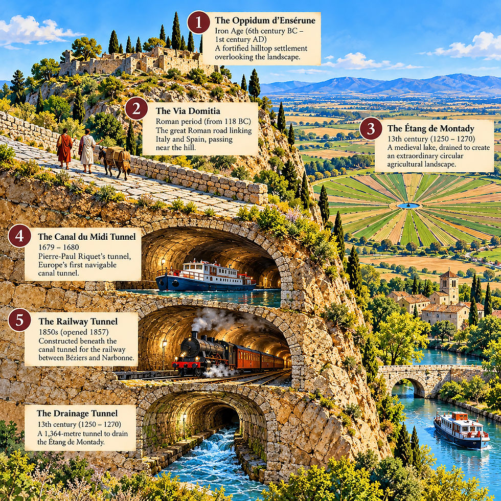
There is a hill near the village of Colombiers, not far from Béziers in southern France, that human beings have been modifying for more than two thousand years.
It is called the Hill of Ensérune.
At first glance, there is nothing particularly remarkable about it. It is a limestone hill surrounded by vineyards, agricultural fields and the familiar Mediterranean landscape of southern France.
But appearances can be deceptive.
During our journey along the Canal du Midi aboard the barge Saraphina, Rex explained that this unassuming hill contained five distinct layers of human history.
Three tunnels, an ancient Roman road, and an Iron Age settlement.
Five different expressions of human ambition, constructed over approximately 2,500 years.
What makes this particularly remarkable is that successive generations returned to essentially the same location, each with different objectives and increasingly sophisticated technology.
The hill became a settlement, an obstacle, an opportunity and eventually a remarkable monument to human ingenuity.
It seems that human beings simply could not leave it alone.

Layer One: The Oppidum d'Ensérune - A Hill Worth Defending
Sixth century BC to first century AD
Long before the Romans arrived in southern France, people recognized the strategic advantages of the Hill of Ensérune.
Its elevated position provided extensive views across the surrounding countryside, making it an attractive location for a fortified settlement.
Beginning around the sixth century BC, an Iron Age community developed on the hill. Over subsequent centuries, the settlement expanded into an important regional center.
Today, archaeologists refer to it as the Oppidum d'Ensérune.
The inhabitants constructed houses, streets, defensive structures and an elaborate system for storing grain. Hundreds of storage silos have been discovered, providing evidence of the settlement's agricultural economy.
The inhabitants maintained trading relationships with communities throughout the Mediterranean, including Greek, Iberian and eventually Roman societies.
The settlement flourished for centuries before gradually declining during the Roman period.
The location was no accident.
From the summit, its inhabitants could observe the surrounding plains, monitor approaching travelers and oversee the agricultural resources upon which their community depended.
The hill provided protection, visibility and strategic advantage.
It was the first chapter in a long history of human beings finding new uses for the same piece of geography.
Layer Two: The Via Domitia - The Romans Arrive
Second century BC
The Romans had their own ambitions for southern France.
In 118 BC, construction began on the Via Domitia, the great Roman road connecting Italy with the Iberian Peninsula.
This was no ordinary road.
It formed part of an extensive transportation network that allowed Roman armies, merchants, administrators and travelers to move efficiently across the expanding empire.
The road passed through the landscape near Ensérune, where the natural geography provided an important passage between surrounding hills.
Roman engineers were accomplished road builders. They understood drainage, gradients, foundations and the importance of selecting efficient routes through difficult terrain.
Unlike the later canal and railway engineers, however, they did not excavate a tunnel through the hill.
They traveled across the landscape.
Their road represented a fundamentally different relationship with the terrain: rather than creating a navigable underground passage, they established a durable surface route.
The Via Domitia continued to influence regional transportation long after the Roman Empire disappeared.
It was the second major chapter in the history of Ensérune.
The hill had become part of an international transportation network.
Layer Three: The Drainage Tunnel - Making a Lake Disappear
Thirteenth century
More than a thousand years later, medieval landowners confronted an entirely different problem.
Immediately below the Hill of Ensérune lay an extensive shallow lake: the Étang de Montady.
To modern eyes, such a wetland might represent valuable wildlife habitat.
To medieval landowners, however, it represented an opportunity to create productive agricultural land.
In 1247, authorization was granted to drain the lake.
The project required an extraordinary combination of surveying, excavation and hydraulic engineering.
Workers constructed a network of drainage channels radiating toward a central collection point. Water was then directed through an underground tunnel beneath the Hill of Ensérune.
The drainage tunnel, approximately 1,364 meters long, allowed the collected water to escape toward the lower-lying wetlands of Capestang.
Gravity did much of the work.
The result was one of the most visually extraordinary agricultural landscapes in France.
The former lake was transformed into a circular arrangement of agricultural fields, divided by drainage channels that radiate outward like the spokes of an enormous wheel.
Viewed from the summit of Ensérune, the pattern resembles a giant sunflower.
The engineering achievement was remarkable, particularly considering the limited technology available to medieval workers.
But the ecological implications are equally interesting.
An entire wetland ecosystem had been transformed into agricultural land.
What medieval society considered progress might be regarded very differently today.
Nevertheless, the drainage tunnel established an important precedent.
It demonstrated that the Hill of Ensérune could be penetrated.
Four centuries later, that knowledge would become particularly valuable.
Layer Four: The Canal du Midi - Riquet Refuses to Go Around
1679–1680
The engineer responsible was Pierre-Paul Riquet.
His Canal du Midi would become one of the most remarkable civil engineering achievements of its time.
But Riquet encountered an obstacle near Colombiers.
The Hill of Ensérune stood directly in the proposed route of his canal.
He could divert the canal around the hill, potentially creating additional engineering difficulties, or attempt something unprecedented.
He chose to go through it.
The result was the Tunnel du Malpas, generally recognized as Europe's first navigable canal tunnel.
Construction began in 1679.
The project was controversial. The geological conditions were difficult, and concerns about the stability of the excavations prompted royal authorities to order work suspended.
According to the traditional account, Riquet was not easily discouraged.
He continued work, and a small team of workers excavated an experimental passage through the hill.
When royal inspectors eventually arrived, Riquet demonstrated that the proposed tunnel was feasible.
Construction proceeded.
The finished passage extended approximately 173 meters, including its approaches, with about 85 meters beneath the vaulted section.
Boats could now pass directly through the hill.
There is something particularly appealing about the relationship between the medieval drainage tunnel and Riquet's achievement.
The earlier engineers had demonstrated that an underground passage was possible.
Riquet took that knowledge and applied it to an entirely different purpose.
The medieval engineers wanted to remove water.
Riquet wanted to transport people and goods upon it.
The same hill.
The same fundamental engineering principle.
Two completely different ambitions.
Layer Five: The Railway - Another Transportation Revolution
Nineteenth century
For approximately 150 years, the Canal du Midi represented an important commercial transportation route across southern France.
Then came the railway.
The Industrial Revolution transformed European transportation. Steam locomotives offered unprecedented speed and the capacity to transport enormous quantities of freight.
Railway engineers constructing the line between Béziers and Narbonne encountered a familiar obstacle.
The Hill of Ensérune.
Once again, engineers decided that the most practical solution was to excavate a tunnel.
During the 1850s, another underground passage was constructed through the hill, beneath the existing Canal du Midi tunnel.
The railway tunnel opened in 1857.
The remarkable result was a hill containing three underground passages, constructed during three different historical periods.
At the lowest level, medieval drainage water continued to flow away from the former Étang de Montady.
Above it, nineteenth-century railway traffic passed beneath the hill.
Higher still, boats navigated the seventeenth-century Canal du Midi.
Three tunnels.
Three different technologies.
Three entirely different purposes.
And above them lay the route of the ancient Roman road and the remains of the Iron Age settlement.
Five layers of history occupying one extraordinary landscape.
A Hill That Tells the Story of Civilization
What fascinates me about Ensérune is not simply the extraordinary engineering.
It is the changing relationship between human beings and the landscape.
The Iron Age inhabitants occupied the hill because it offered protection and strategic advantage.
The Romans recognized the surrounding terrain as an important transportation corridor.
Medieval landowners regarded the nearby lake as an agricultural opportunity and excavated a tunnel to drain it.
Pierre-Paul Riquet saw the hill as an obstacle to inland navigation and excavated another tunnel.
Nineteenth-century railway engineers encountered the same obstacle and constructed yet another passage.
Each generation inherited the achievements of its predecessors.
Each applied the technology available at the time.
And each modified the landscape according to its own priorities.
There is also an intriguing contrast between the different projects.
The medieval drainage tunnel removed water from the landscape.
The Canal du Midi introduced an artificial waterway into it.
The railway subsequently offered an alternative means of transportation that would eventually reduce the canal's commercial importance.
What one generation regarded as an essential technological achievement could be superseded by the next.
Yet all three tunnels survive.
They are physical reminders that technological progress is cumulative rather than simply a succession of replacements.
The Sixth Layer?
Standing above the Étang de Montady today, looking across its extraordinary geometric fields, it is tempting to imagine what the next generation might contribute to this landscape.
Perhaps the most important future achievement will not involve excavating another tunnel, constructing another road or transforming another ecosystem.
Perhaps it will involve conservation.
The Canal du Midi is now a UNESCO World Heritage Site. The Oppidum d'Ensérune is an important archaeological monument. The former Étang de Montady remains an extraordinary example of medieval agricultural engineering.
Together, they offer an opportunity to understand how successive civilizations have interacted with the natural environment.
There is something reassuring about the possibility that the next great human contribution to this landscape might involve protecting what previous generations created.
And perhaps restoring some of what they destroyed.
After 2,500 years of occupation, construction, excavation and modification, the Hill of Ensérune might finally deserve a little peace.
But I suspect human beings will find another reason not to leave it alone.


Comments